WERA Remote Ocean Sensing System
WERA Remote Ocean Sensing System
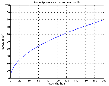
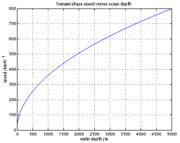
WERA is an emerging remote ocean current sensing system (available since 2001) to be installed at the coast. It produces current maps which provide data from up to 200 km offshore and are updated every four minutes. A tsunami that travels in deep water with speeds of more than 700 km/h reduces its speed at the continental shelf edge while it increases its wave height. As the tsunami undergoes this change the resulting typical current pattern, can be detected by means of the WERA system.
In many cases where the coast is exposed to tsunami threats, the shelf edge is located 100 km or more off the coast. In shallower water, a tsunami’s wave speed is reduced to around 100 km/h which allows for a warning time of 1 hour or more.
Therefore, WERA can be used as a powerful instrument in a local tsunami warning system.